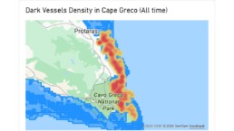

More than two thousand detections at Lady’s Mile, Latsi-Akamas and Cavo Greco within the months of June-August highlight distinct activity patterns and the value of stronger observation in sensitive coastal waters.
Satellite observations recorded 2,060 vessel detections across Lady’s Mile, Latsi-Akamas and Cavo Greco during selected summer periods in 2024 and 2025, providing a new perspective on the environmental disturbances inside three of Cyprus’s more important Marine Protected Areas (MPAs). These areas protect ecologically valuable coastal habitats, including Posidonia oceanica meadows, which provide important nursery and feeding grounds for marine species, support biodiversity, and contribute to coastal protection and carbon sequestration. Because this seagrass grows very slowly, damage can happen in seconds and persist for decades, making the prevention of damage particularly important.
The analysis used the AI-empowered vessel detection service of PERIOPSIS LTD based on visible satellite imagery, to detect vessels at sea, comparing detections with the Automatic Identification System (AIS) data, a vessel-tracking system through which ships share information on their identity and journey. Of the 2,060 detections, 1,114 — about 54% — had no matching AIS signal in the available data, revealing a substantial visibility gap between what could be seen from space and what appeared in conventional tracking systems, emphasizing the importance of remote sensing in such surveys.
The satellite snapshots do not reconstruct complete vessel journeys, but they show repeated vessel presence and where activity clusters. As the analytics consider once-per-day passage of a satellite, the actual detections could be many more than those 2,060. Used alongside AIS and patrols, satellite monitoring can help build a fuller picture of activity in sensitive waters and identify persistent monitoring blind spots.
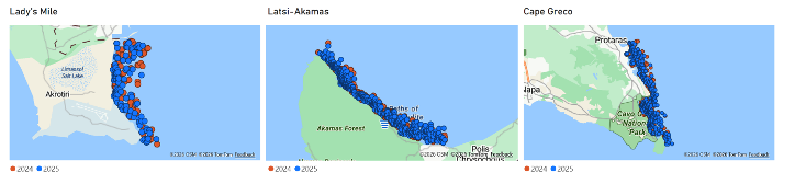
Figure 1. Vessel Detections across the three MPAs, July and August 2024 and 2025
The Latsi-Akamas MPA was the most frequently visited of the three areas, accounting for almost half of all vessel detections and showing the highest activity on satellite observation days in both years. Latsi-Akamas recorded 1,026 detections, including 738 without an AIS match. Cavo Greco recorded 746 detections, of which 444 were AIS-matched and 302 unmatched. Lady’s Mile recorded 288 detections, with 214 matched and 74 unmatched. Unmatched detections may reflect legitimate tourism, recreational boating or other uses, but they can also point to unreported or potentially illegal activity at sea, including fishing, transportation of goods or other activities. The differences show why monitoring needs to be tailored to each protected area. Time series graphs indicate that July and August are busier months than June.
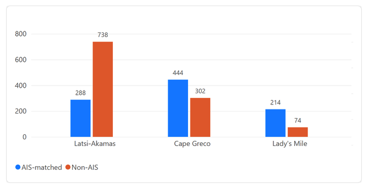
Figure 2. AIS-Matched vs Non-AIS Vessels across all detections
Across the three MPAs, detections during July–August were around 17% lower in 2025 than in 2024, with the largest decrease at Lady’s Mile, while activity at Cavo Greco remained broadly similar. Within the summer season, lower activity was observed in June, increasing in July and August when differences in the number of satellite observation days are taken into account. Overall, August showed the highest level of vessel activity in both years.
Comparing the same period across the two years, observed activity decreased at Latsi-Akamas and Lady’s Mile in 2025, while Cavo Greco remained broadly stable.

Figure 2. Comparison of vessel detections across the three MPAs, between July and August 2024 and 2025.
Importantly, around 60% of sampled vessel detections were classified as non-moving at the moment they were observed. While this does not confirm that vessels were anchored, it identifies locations that may warrant closer attention. That is particularly relevant for the protected and priority habitat Posidonia oceanica. Anchors and chains can physically damage Posidonia meadows when repeatedly dropped or dragged across the seabed, and anchoring is recognised as a major impact of recreational boating in Mediterranean MPAs. This pressure is also highlighted in WWF’s reports on Mediterranean seagrass, which identifies Cyprus among the region’s anchoring hotspots.
Combining maps of vessel activity with maps of P. oceanica can highlight places where vessel pressure and sensitive seabed habitats may intersect. The heatmaps below show where detections are most concentrated across the three areas.
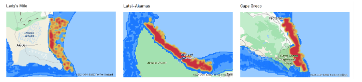
Figure 4. Heatmap of detected vessels in the three protected areas. Dark blue indicates presence of Posidonia (Posidonia Data source: Department of Environment, Republic of Cyprus). In most cases, the heatmap coincides with the protected Posidonia oceanica seagrass presence.
The findings demonstrate how satellite technology, together with AI, can be used for daily monitoring of Cyprus’s sensitive marine areas, so that changing hotspots and persistent visibility gaps can be recognised over time. Satellite technology would not replace patrols or existing vessel-tracking systems. It can complement them with an independent layer of information, helping authorities and conservation organisations focus attention where it is most needed.
These insights can provide policymakers and environmental authorities with clear, evidence-based information of the scale and distribution of vessel activity within sensitive MPAs. By making otherwise hard-to-observe disturbances visible and measurable, the research highlights the pressures on protected habitats such as Posidonia oceanica and support more informed decisions on monitoring, enforcement and management measures. The evidence can also strengthen the case for timely action to ensure that the designation of MPAs translates into effective protection and long-term conservation outcomes.
Marine protection depends not only on drawing boundaries, but on understanding what is happening within them. There is an urgent need to establish what vessels are doing in these hotspots. Combining regular satellite observations with on-water monitoring and seabed surveys would help identify anchoring pressure, assess potential impacts and protect important marine ecosystems and the species they support.
The study was conducted by PERIOPSIS Ltd, Marine and Environmental Research (MER) Lab, and Mr. Finn Lageveen, a Creative Technologies’ student at the University of Twente, the Netherlands.
For more visualizations and analytics generated through this study, check here: https://www.periopsis.com/blog/vessels-in-cypruss-protected-waters/


Related News.

Shipbuilding Labor talks hit fresh snags after tentative deal rejected
This year’s wage and collective bargaining negotiations in the shipbuilding industry are drifting back into uncertainty just as they appeared to be…
SEA.AI brings Machine Vision to multiple USV platforms at NATO’s REPMUS 2026
Maritime AI specialist demonstrated a shared perception layer across crewed and uncrewed vessels during the Portuguese Navy-led exercise, held in…
Clean tanker markets size up impact of potential US diesel export curbs
HIGHLIGHTS Trump floats diesel export ban amid soaring prices MR tanker demand could fall by 1.35 million b/d Russian diesel exports…
RINA and PTT sign strategic agreements to advance innovation and decarbonization across the energy and maritime sectors
RINA, the inspection, certification and engineering consulting multinational, announces the signing of two Memoranda of Understanding with PTT…
The Port Authority and Valencia City Council launch the countdown to the River Mouth Park
The Port Authority of Valencia (APV) and Valencia City Council have reached an agreement on the River Mouth Park setting out the commitments of both…

Newbuild order for two very large ammonia acriers in combination with long term time charters
SFL Corporation announced that it has agreed to build two 93,000 cbm Very Large Ammonia Carriers. The vessels will be able to carry a wide range of…

xclusiv S&P Report 05th October 2026
Pls find below the [xclusiv] S&P Report 05th October 2026 [xclusiv] 2026_10_05

Volare Shipping completes listing on Euronext Growth Oslo
Volare Shipping, the Trafigura Group company established to own, operate and scale a modern fleet of oil tankers, commenced trading on Euronext…

Maritime must move beyond wellbeing awareness to change crew behaviour, says WellAtSea
The maritime industry risks mistaking wellbeing activity for wellbeing progress unless it places greater emphasis on whether programmes are changing…
AD Ports Group successfully completes acquisition of Brazil’s CLI upon receiving full regulatory approvals
Acquisition expands AD Ports Group’s geographic footprint into South America and strengthens its agrifoods business vertical · AD Ports…
Subscribe to our newsletter!
if you dont want to swim alone in the ocean of news, sign up for the newsletter, and you will receive daily all the important news of world shipping!
