The end of benign navigation Shipping must prepare for a world of unreliable signals
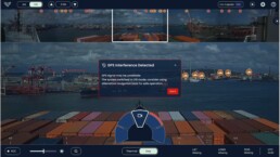

Maritime navigation systems were made for a world with reliable location data. But when GPS spoofing becomes a tool in modern warfare, playing havoc with traditional navigation systems, shipping companies should rethink bridge operations to keep navigation safe, says Yarden Gross, CEO and Co-founder of Orca AI.
Reports of vessels in the Persian Gulf having their GPS signals spoofed and others transiting the Strait of Hormuz with AIS signals switched off have drawn attention to a growing operational reality for commercial shipping.
In areas where tensions are high with a credible threat to merchant vessels, operators may face new dilemmas – Do you maintain visibility through a cooperative system such as AIS? Do you continue to sail while relying on the radar alone as ECDIS is misleading due to GPS interference?
The circumstances influencing these decisions are complex. But the situation highlights a broader issue the industry must confront: modern navigation relies heavily on satellite-based signals that are increasingly vulnerable.

Limits of conventional systems
AIS and GPS have become a cornerstone of maritime safety. By broadcasting identity, position, course and speed, AIS enables vessels and shore authorities to understand traffic movements well beyond visual range. The vessel’s location and identifying details are shown on the radar and ECDIS, helping the bridge team build a coherent picture of surrounding traffic.
Satellite positioning systems such as GPS underpin this navigational framework. From ECDIS positioning to route planning and voyage optimization (including reducing grounding risk), reliable GPS positioning has become the shared reference point for both onboard and shore offices. If your GPS signals are compromised you are left only with radar and your watchkeepers’ eyes, which is especially hazardous in darkness.
Normalization of signal interference
The Gulf and Strait of Hormuz is the latest and most acute example of this growing vulnerability. Widespread GPS and AIS interference following the military escalation has reportedly disrupted the navigation systems of more than 1,650 commercial vessels across the Gulf. In some cases, tracking data has shown ships located at airports, on land or going around in circles – classic indicators of spoofing.
This interference can originate not only from land-based systems but also from other vessels, including ships engaged in sanctioned or “shadow fleet” activity, adding further uncertainty to the navigational environment.
Including the withdrawal of war-risks insurance, the present situation has sparked severe operational disruption. More than 150 tankers and LNG carriers are currently anchored or waiting in the Gulf as operators delay Hormuz transits. With parts of the compliant tanker fleet sitting idle or rerouting, day rates have surged to record levels of USD 700,000-plus per day.
The consequences extend far beyond individual vessels. Disruption to the movement of oil and gas to global markets is creating severe knock-on effects not only for maritime supply chains but for the wider world economy.
The result of sustained GNSS interference is effectively an ‘electronic fog’ as the shared digital picture of maritime traffic – the foundation on which many monitoring and navigation systems depend – becomes unreliable or misleading. This phenomenon has also become increasingly common in other regions affected by geopolitical tension, such as the Baltic and Black Seas, rapidly making what were once considered exceptional disruptions into normal operational risk.
New layers of perception
The traditional methods to maintain situational awareness at sea include radar interpretation, human watchkeeping and manual cross-checking of navigational information on the ECDIS.
Mariners have always understood the value of layered awareness. No single sensor or system should be relied upon in isolation. Radar detects physical objects regardless of whether they transmit signals. Human lookout remains a legal and operational requirement under the COLREGs. Electronic charts provide geographic context. Together, these tools allow navigators to verify what they see.
In today’s increasingly complex environment, new technologies are strengthening this layered model. And unlike AIS, they do not depend on other vessels transmitting information.
Computer vision and AI now allow visual data from cameras (including thermal cameras) installed around a vessel to be analysed continuously, detecting and classifying objects in real time. By providing an independent visual reference of surrounding vessels and obstacles, and alerting the bridge team when risks emerge, AI-assisted situational awareness provides an additional, independent layer of perception alongside radar and human lookout.
These technologies are not intended to replace seafarer judgement or traditional navigational systems. They are designed to complement them, helping bridge teams maintain situational awareness in critical conditions such as darkness, poor visibility, congested waterways or when positioning and tracking data become unreliable.
Networked awareness further reinforces this model by creating what we call a ‘collective mind’ of sea captains. In an era where ships are no longer ‘islands,’ cloud connectivity allows the visual detections of one vessel to act as a sensor for the entire fleet. When interference or signal degradation is detected, these real-time hotspots are mapped and shared instantly. This gives navigators (and just as importantly, shore-side fleet managers) the ‘digital truth’ needed to recognize and respond to disruptions before they become crises, transforming the bridge team from reactive lookouts into proactive system supervisors.
A navigational sea change
The crisis in the Gulf illustrates a broader shift across the maritime domain. For decades, AIS and satellite positioning operated in a largely benign environment. That assumption is increasingly being challenged as electronic interference becomes a routine feature of geopolitical conflict.
The question is therefore not whether AIS, GPS or other digital systems will remain central to navigation – they will. But whether vessels can maintain safe situational awareness when those signals fail.
The sea has always demanded caution and preparation. And in an era where the digital picture can go dark without warning, ensuring ships can still navigate safely is an essential responsibility – and AI-powered situational awareness is part of that.


Related News.

Navigating the Multi-Orbit Era: In Conversation with Intellian’s Jon Harrison at SMM 2026
At SMM 2026 in Hamburg, the rapid evolution of maritime satellite communications took centre stage. Across the exhibition halls, discussions among…
Cyprus ports need joint energy and investment strategy, shipping agents chief says
Cyprus needs a coordinated strategy for shipping, energy and environmental protection to support port investment and modernisation, Cyprus shipping…

MASO Public Affairs introduces MASO Regulatory Intelligence
A new subscription service helping businesses understand what is changing and what it means for them MASO Public Affairs introduces MASO Regulatory…
Anglo-Eastern helps turn CMBTECH’s ammonia ambition into an operational reality
From early feasibility study and risk-based design to newbuilding supervision, crew readiness and technical management, Anglo-Eastern drew on its…

Escalation of attacks threatens to derail recovery in Middle East oil exports
World oil demand is forecast to fall by 2.5 mb/d y-o-y in 4Q26 and 2.6 mb/d on average in 2026. As the Iran war manifests itself through restricted…
New study finds shipping pays twice its share to EU ETS earmarked revenues should triple to help build market for sustainable fuels and technologies
Shipping is responsible for around 10% of EU ETS emissions but pays almost 20% of the ETS bill. Unlike other sectors, it has never received free…

MSARC strengthens maritime mass rescue readiness through training and national live exercise off Dakar, Senegal
Joint MSARC–FHAS programme combines three days of SAR training with a national multi-agency live exercise The Maritime Search and Rescue Council ,…
Sogese report deliveries are still being delayed as container freight rates fluctuate
FOR IMPORTERS Spot rates into the Mediterranean are back at January levels, Far East to Europe reliability sits at pandemic lows, and nearly…

Glencore begins trading on Australian Securities Exchange
Glencore has begun trading on the Australian Securities Exchange under the ASX code GLC. Gary Nagle, Glencore’s CEO, said it was an exciting day for…
BIMCO Shipping Number of the Week
Suez Canal container ship transits exceed 50% of pre-disruption levels "During the first two weeks of October, weekly container ship capacity…
Subscribe to our newsletter!
if you dont want to swim alone in the ocean of news, sign up for the newsletter, and you will receive daily all the important news of world shipping!
