ICEYE and SATIM announce launch of ‘Detect & Classify’ product for AI-powered analysis of SAR imagery
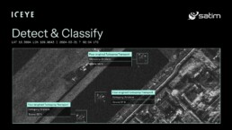
ICEYE, the global leader in Synthetic Aperture Radar (SAR) satellite operations, together with SATIM, the provider of state-of-the-art solutions for SAR data analytics, today announced the launch of Detect & Classify – an AI-powered product that accelerates the transformation of satellite imagery into actionable intelligence. The product combines ICEYE’s high-resolution SAR imagery with SATIM’s advanced artificial intelligence to automatically detect and classify vessels, aircraft, and vehicles in ICEYE imagery with better than 90% accuracy.
The Detect & Classify product bundles ICEYE imagery with SATIM’s AI-based imagery derivatives, delivering both the SAR image and detections and classifications of objects in the image in a single, high-confidence package. This product delivers a new level of rapid situational awareness across maritime, air, and land domains, providing powerful support to SAR analysts and their missions within the armed forces and intelligence agencies. This product launch follows a successful joint development effort between ICEYE and SATIM, first announced in February 2025.
The Detect & Classify product, brought to market by ICEYE and powered by Satim’s unique AI capabilities, responds to a long-standing challenge with manual SAR data analysis. Traditionally, defense and intelligence organizations have relied on time-consuming manual analyses of imagery by SAR experts to extract valuable intelligence. Detect & Classify empowers SAR imagery users – no longer just SAR experts – to shorten this cycle by automating the delivery of actionable insights about what the imagery captures. ICEYE routinely delivers imagery within hours or in some cases minutes, and the Detect & Classify derivatives are delivered on the same timelines.
Intelligence analysts can now more quickly establish patterns of behavior in larger volumes of imagery; tactical teams can rapidly locate and classify assets for targeting, and maritime forces can more effectively identify and intercept illicit “dark vessels.”
“Our goal with Detect & Classify is to empower our customers to make faster, more informed decisions with less effort,” said John Cartwright, Senior VP of Data Product at ICEYE. “This is more than just an analytics tool — we’re eliminating a bottleneck between satellite imagery pixels and decision-making, giving our users near-instant situational awareness. And it’s a transformative step on the path towards ‘lights-out,’ machine-driven satellite imaging operations. That’s a fundamental shift for defense, security, and intelligence operations that use satellite imagery.”
Jacek Strzelczyk, CEO of SATIM, added: “Combining SATIM’s extensive object catalog with ICEYE’s high-fidelity SAR imagery creates a powerful product that eliminates manual analysis bottlenecks and provides customers with direct access to actionable intelligence, improving situational awareness and accelerating critical decisions. We’ve seen significant uptake of our products with customers around the globe, and this product will expand this benefit to a wider range of customers.”
ICEYE owns and operates the world’s largest SAR satellite constellation, delivering global access and the highest revisit frequency on the market. ICEYE SAR satellites provide 25 cm ground resolution, enabling accurate object detection and classification and situational awareness in all weather and lighting conditions. To date, ICEYE has launched 54 SAR satellites into orbit for its own and customers’ use.
The recent introduction of ICEYE’s new Scan Wide imaging mode further strengthens this capability, allowing for coverage of up to 60,000 km² in a single scene. This broad-area surveillance mode is particularly useful for Detect & Classify in maritime and large-scale monitoring efforts, enabling users to rapidly identify areas of interest before tasking higher-resolution modes for more detailed analysis.



Related News.

Navigating the Multi-Orbit Era: In Conversation with Intellian’s Jon Harrison at SMM 2026
At SMM 2026 in Hamburg, the rapid evolution of maritime satellite communications took centre stage. Across the exhibition halls, discussions among…
Cyprus ports need joint energy and investment strategy, shipping agents chief says
Cyprus needs a coordinated strategy for shipping, energy and environmental protection to support port investment and modernisation, Cyprus shipping…

MASO Public Affairs introduces MASO Regulatory Intelligence
A new subscription service helping businesses understand what is changing and what it means for them MASO Public Affairs introduces MASO Regulatory…
Anglo-Eastern helps turn CMBTECH’s ammonia ambition into an operational reality
From early feasibility study and risk-based design to newbuilding supervision, crew readiness and technical management, Anglo-Eastern drew on its…

Escalation of attacks threatens to derail recovery in Middle East oil exports
World oil demand is forecast to fall by 2.5 mb/d y-o-y in 4Q26 and 2.6 mb/d on average in 2026. As the Iran war manifests itself through restricted…
New study finds shipping pays twice its share to EU ETS earmarked revenues should triple to help build market for sustainable fuels and technologies
Shipping is responsible for around 10% of EU ETS emissions but pays almost 20% of the ETS bill. Unlike other sectors, it has never received free…

MSARC strengthens maritime mass rescue readiness through training and national live exercise off Dakar, Senegal
Joint MSARC–FHAS programme combines three days of SAR training with a national multi-agency live exercise The Maritime Search and Rescue Council ,…
Sogese report deliveries are still being delayed as container freight rates fluctuate
FOR IMPORTERS Spot rates into the Mediterranean are back at January levels, Far East to Europe reliability sits at pandemic lows, and nearly…

Glencore begins trading on Australian Securities Exchange
Glencore has begun trading on the Australian Securities Exchange under the ASX code GLC. Gary Nagle, Glencore’s CEO, said it was an exciting day for…
BIMCO Shipping Number of the Week
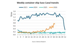
Suez Canal container ship transits exceed 50% of pre-disruption levels "During the first two weeks of October, weekly container ship capacity…
Subscribe to our newsletter!
if you dont want to swim alone in the ocean of news, sign up for the newsletter, and you will receive daily all the important news of world shipping!
