‘Theyr’ A.I. industry platform answers Shippings’ environmental challeng


To meet the requirements of the new mandatory regulations companies strive to further reduce their GHG emissions and that presents some real questions:
- Do you have a roadmap how to achieve these new goals and targets?
- Can the latest Voyage Optimisation A.I. tools provide a solution?
- How can you accelerate the use of advanced A.I. technologies?
- Does High Fidelity Met-Ocean Forecast data really improve performance and analysis?
Integrating new technological solutions is vital to meet the new requirements. Low speed and low-fidelity data as well as outdated voyage optimisation algorithms are a drawback that will result in inefficient operations, lost time and money
A.I. tools are an integral part of the solution
A high-performance voyage optimisation engine, capable of solving the challenges of the industry by utlising the very latest advances in A.I.
It is ideally suited for Maritime Solution providers that require a highly adaptable and effective voyage optimisation engine that significantly improves ship performance and efficiencies.
The flexibility of this high-performance tool encourages seamless integration of multiple environmental and operational modules that exist within the industry.
Current optimisation parameters include:
- Input: High fidelity Met-Ocean data, Ship Performance Models and Navigable Routing Tools.
- Optimisted Route Output: Weather & Ocean Forecasts, Speed, Fuel, ETA (JITA, PTA) and Safety Parameters.
Uniquely, all parameters and modules are interchangeable with third party solutions. Additional modules may also be applied.

Improving performance and analysis
The implementation of our data is through our high-performance Rapid Data Access Service (RDAS), which provides virtual real-time delivery of high-fidelity met-ocean data for route analysis that significantly reduces data transfer and handling requirements.
~1000 data points per millisecond performance ensures a solution that enhances your met-ocean data analysis operations.
Our WMS-API (Web Mapping Service) is producing on-the-fly map overlays for the exact area you require for each request.
Producing an effective animation rate with full functionality and forecast parameters are key to provide the most accurate image with a myriad of features.



Related News.

Navigating the Multi-Orbit Era: In Conversation with Intellian’s Jon Harrison at SMM 2026
At SMM 2026 in Hamburg, the rapid evolution of maritime satellite communications took centre stage. Across the exhibition halls, discussions among…
Cyprus ports need joint energy and investment strategy, shipping agents chief says
Cyprus needs a coordinated strategy for shipping, energy and environmental protection to support port investment and modernisation, Cyprus shipping…

MASO Public Affairs introduces MASO Regulatory Intelligence
A new subscription service helping businesses understand what is changing and what it means for them MASO Public Affairs introduces MASO Regulatory…
Anglo-Eastern helps turn CMBTECH’s ammonia ambition into an operational reality
From early feasibility study and risk-based design to newbuilding supervision, crew readiness and technical management, Anglo-Eastern drew on its…

Escalation of attacks threatens to derail recovery in Middle East oil exports
World oil demand is forecast to fall by 2.5 mb/d y-o-y in 4Q26 and 2.6 mb/d on average in 2026. As the Iran war manifests itself through restricted…

New study finds shipping pays twice its share to EU ETS earmarked revenues should triple to help build market for sustainable fuels and technologies
Shipping is responsible for around 10% of EU ETS emissions but pays almost 20% of the ETS bill. Unlike other sectors, it has never received free…

MSARC strengthens maritime mass rescue readiness through training and national live exercise off Dakar, Senegal
Joint MSARC–FHAS programme combines three days of SAR training with a national multi-agency live exercise The Maritime Search and Rescue Council ,…

Sogese report deliveries are still being delayed as container freight rates fluctuate
FOR IMPORTERS Spot rates into the Mediterranean are back at January levels, Far East to Europe reliability sits at pandemic lows, and nearly…

Glencore begins trading on Australian Securities Exchange
Glencore has begun trading on the Australian Securities Exchange under the ASX code GLC. Gary Nagle, Glencore’s CEO, said it was an exciting day for…
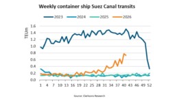
BIMCO Shipping Number of the Week
Suez Canal container ship transits exceed 50% of pre-disruption levels "During the first two weeks of October, weekly container ship capacity…
Subscribe to our newsletter!
if you dont want to swim alone in the ocean of news, sign up for the newsletter, and you will receive daily all the important news of world shipping!
